Smart Bay Santa Teresa Underwater Observatory is an infrastructure of Smart Bay Santa Teresa cooperation platform, empowered through the fundings of Recovery and Resilience Plan dedicated to strengthening of EU research infrastructures, such as EMBRC-UP project (Unlocking the potential for health and food from the seas) and Regional Innovation Ecosystems, such as Ligurian RAISE (Robotics and AI for Socio-economic empowerment). Furthermore, the observatory is the result of a collaboration between Smart Bay Santa Teresa and local stakeholders, including the Natural Regional Park of Porto Venere and Navy commands.
Based on Internet of Underwater Things technology (IoUT) for data transmission, the observatory includes five stations, one in the bay of Santa Teresa (green), two in the shellfish farming area (red) and two in the Regional Natural Park of Porto Venere (blue) (Figure 1).
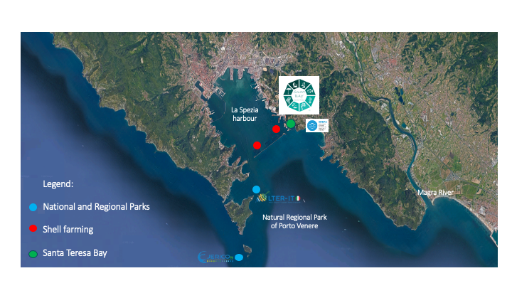
Figure 1. Stations of the Smart Bay Santa Teresa underwater observatory and their connection with EU infrastructures (eLTER and JERICO).
The observatory is divided into three subsystems to ensure optimal data transmission management: Santa Teresa, Porto Venere and Tinetto. All subsystems are equipped with underwater acoustic modems (nodes) for data transmission, equipped with a temperature sensor and high-precision probes for acquiring physical and chemical parameters:
- N° 2 ProOceanus CO2-Pro CV sensor measuring the partial pressure of CO2 gas dissolved in water using infrared detection; this sensor is ideal for carbon capture storage monitoring and deep ocean CO2 fluxes;
- N° 4 YSI EXO 2 model multiparametric probes providing real-time data on water quality by measuring: temperatures, conductivity, pH, dissolved oxygen, turbidity and Chlorophyll;
- N° 5 Z-Pulse Doppler current meters, single-point current sensors, based on the backscatter acoustic Doppler principle, for measuring current speed and direction in the sea;
- N° 1 SeaBird SBE19plus V2 CTD multiparametric probe with oxygen sensors SBE43 and SBE63 and added Optode optical sensor for oxygen measurement, which will provide vertical profiles on the water column with measurements of temperatures, conductivity, dissolved oxygen, turbidity and Chlorophyll. It is also used to calibrate sensors that remain fixed at sea. Optode is designed to measure absolute oxygen concentration and % saturation and is based on the ability of selected substances to act as dynamic fluorescence quenchers;
- N° 1 Noretk AWAC ADCP, measuring direction and speed current profiles along the water column;
- N° 2 Seabird SeaPhOx, SBE37-SMP- ODO multiparametric probes with SeaFET sensor for pH measurements, which will provide measurements on sea water temperatures, conductivity, pH, dissolved oxygen, turbidity and Chlorophyll;
- N° 1 GUARD-ONE, image acquiring autonomous system that will provide underwater images from the shellfish farming.
Santa Teresa system (Figure 2) is located within the Gulf of La Spezia, between 3 and 10 metres of depth. Comprising 10 data transmission nodes, it is the most complex system of the observatory and includes one station inside Santa Teresa Bay and two stations within the shellfish farming, inside the dam. All 10 nodes are equipped with a temperature sensor, six of of them are connected to high-precision probes for the acquisition of parameters such as temperature, salinity, oxygen, chlorophyll, turbidity, pH and current. One node is equipped with a pCO2 sensor. Specifically, the stations S6 and S10, S02 and S09 are located in the shellfish farming area, whereas S05 and S07 are deployed in Santa Teresa Bay. The probes acquire data once per hour and, thanks to the network of nodes, they are acoustically transmitted to the GSM modem (Gateway). The gateway receives the marine data through a hydrophone (S00, Figure 2) and it is kept in the Cooperativa di Mitilicoltori Associati (Mussel Farmers’ Cooperative).
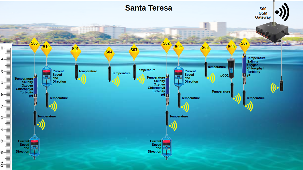
Figure 2. Santa Teresa system: transmission nodes (10), high-precision probes (8) with related acquired parameters, and gateway with hydrophone.
The Porto Venere system (Figure 3), deployed between 2.5 and 7 metres of depth, consists of three data transmission nodes (P01-P03), each one equipped with a temperature sensor. Specifically, two nodes (P01 and P03) are equipped with high precision probes acquiring: temperature, salinity, oxygen, chlorophyll, turbidity and pH. Node P01 is located in the shellfish farming area towards Palmaria Island, whereas node P03, equipped with a current meter acquiring surface current speed and direction, is located at Porto Venere, near the gateway. The probes acquire data once per hour and, thanks to the network of nodes, they are acoustically transmitted to gateway (P00, Figure 3), kept in Porto Venere.
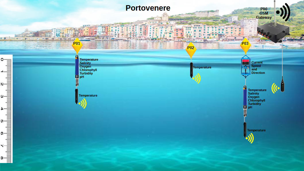
Figure 3. Porto Venere system: transmission nodes (3), high-precision probes (3) with related acquired parameters, and gateway with hydrophone.
The Tinetto system (Figure 4), deployed between 8 and 22 metres of depth, represents the “blank” of the observatory, as it is located in the Porto Venere Regional Natural Park, outside the Gulf. This subsystem consists of two components: one on land, located on Tino island (fully protected site) and equipped with a gateway and hydrophone (T00), and the other one at sea, positioned on the buoy of the marine protected area (T01). T01 is equipped with high precision probes acquiring: temperature, salinity, oxygen, chlorophyll, turbidity, pH and pCO2. This system is also provided with a profiler (ADCP) measuring the speed and direction of the current through the water column. The probes acquire data once per hour and, thanks to the network of nodes, they are acoustically transmitted to gateway (T00, Figure 4), powered by a solar panel.
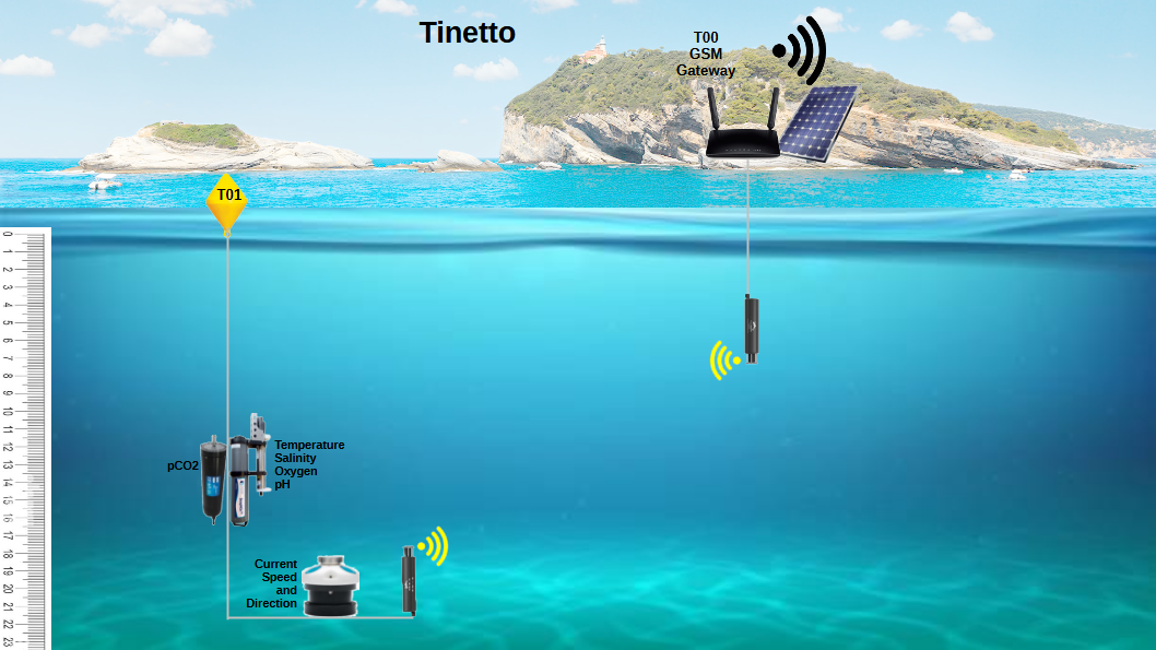
Figure 4. Tinetto system: transmission node (1), high-precision probes (3) with related acquired parameters and gateway with hydrophone.
Smart Bay Santa Teresa underwater observatory is part of European research infrastructures and networks. Specifically, all the observatory’s systems are included among the services of the EMBRC (European Marine Biological Resource Centre) infrastructure, which is present in the area with the ENEA Marine Environment Research Centre in Santa Teresa. The Porto Venere and Tinetto systems are part of the Eastern Ligurian Sea site of the eLTER network, and the Tinetto system alone will contribute to the JERICO infrastructure, together with the smart observatory developed by the CNR (SmartOb) as part of the PNRR ITINERIS “Empowering Italy’s Environmental Future” project. All acquired data are available on data centres with CC-BY licence according to EU Policy on Open Data.
The data acquired through Smart Bay Santa Teresa underwater observatory are analytically validated. Seawater samples are collected monthly through campaigns conducted by ENEA and carbonate systems, oxygen, chlorophyll and nutrients are analysed via instrumentation empowered through EMBRC-UP and ITINERIS PNRR programmes.
Smart Bay Santa Teresa underwater observatory represent a centre of excellence for marine environmental monitoring in the Mediterranean. Thanks to its integration into the European research networks EMBRC, eLTER and JERICO, the data collected contributes to our understanding of climate change and the protection of marine biodiversity, providing valuable information for the sustainable management of marine resources.
Observatory’s data in the form of tables and graphs, are available at the following sections:
.png)
.png)
.png)
Credits: Smart Bay Underwater Observatory management and drawings: Andrea Bordone (ENEA)